How the CAA misrepresented radar data to sustain a false infringement finding
I'm sharing my experience with the UK CAA's airspace infringement process because what I've uncovered reveals a system that fundamentally fails to meet basic standards of natural justice — a scandal waiting to happen, bearing a striking resemblance to the Post Office Horizon affair.
In February 2025, I flew to Guernsey. Shortly afterwards I was accused of clipping the corner of the Solent CTA by a few metres at the very corner. On checking, my GPS track data clearly showed my aircraft remained outside controlled airspace at the closest point. Close, yes — but not infringing.
As an engineer having worked on location systems a various stages throughout my life, I immediately knew the radar was in error. I responded to the Mandatory Occurrence Report explaining that radar cannot accurately locate an aircraft within such tight margins, and enclosed my GPS track as evidence. What followed was not an impartial investigation.
The phone call
The CAA official handling my case telephoned me in a manner solely designed to elicit incriminating statements rather than establish facts. He refused to disclose the radar's error margins, claiming it was accurate "to a few centimetres" — a claim so rediculous I almost laughed as I wasn't sure how someone at the CAA could be so ignorant. He dismissed my GPS data as "unreliable," despite the CAA's own publications stating GPS is accurate to less than 10 metres. He told me my pre-flight planning was defective because I hadn't used a protractor and a paper chart. He chastised me for not filing a MOR myself — which was absurd, because there was no infringement to report.
This was not a fact-finding exercise. It was a process designed to sustain a finding of guilt, conducted in a way that bore no resemblance to the impartial investigation the CAA is obligated to carry out under its own CAP 1404 procedures.
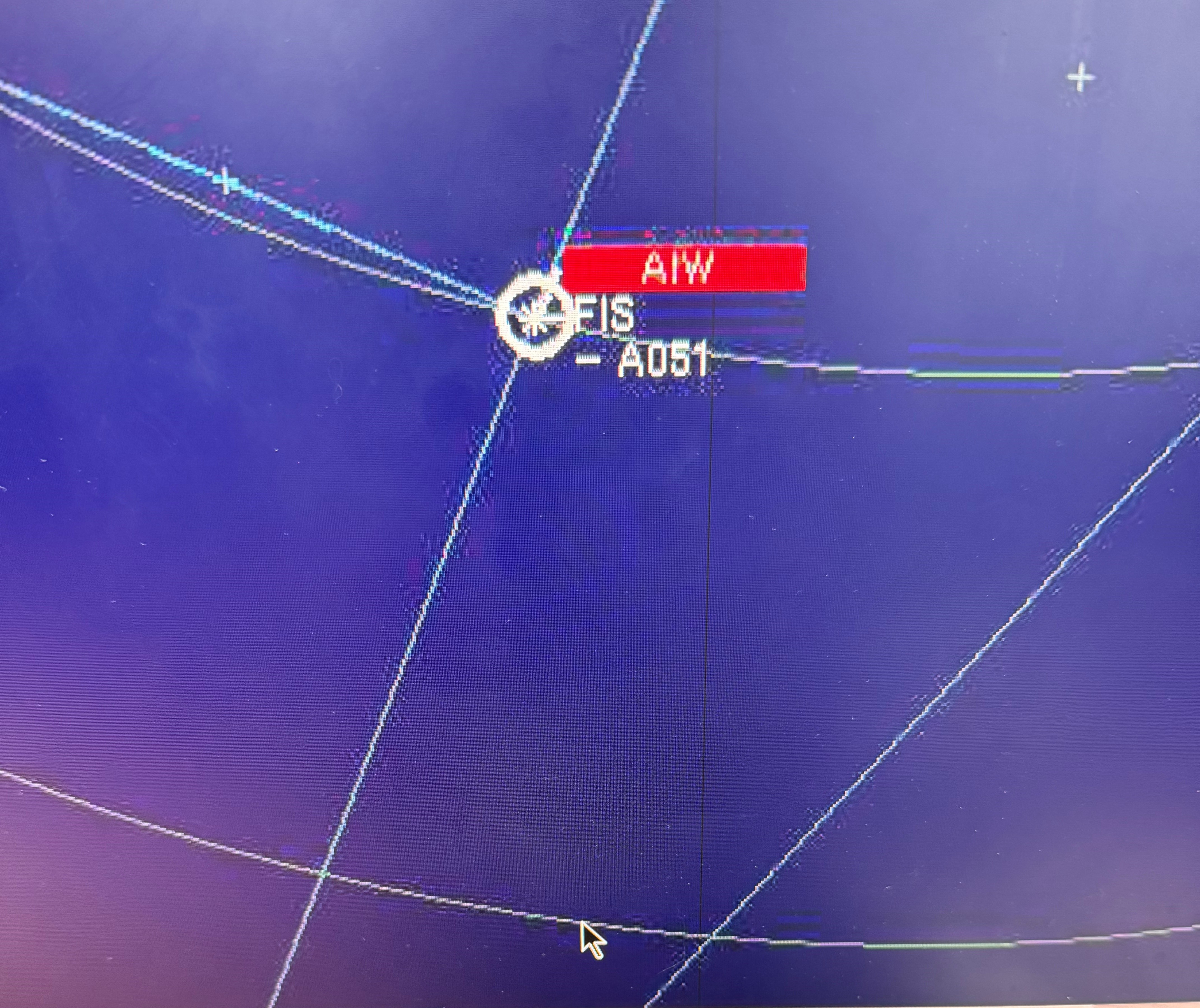
Getting the radar traces
Determined to get to the bottom of this, I wrote to NATS requesting the actual radar traces under UK GDPR. They refused, claiming the data wasn't available in a "common electronic format." This is not a valid ground for refusing a Subject Access Request — a gross misunderstanding of the law.
I appealed to the Information Commissioner, who found in my favour and compelled NATS to disclose everything. What was the data they had claimed couldn't be provided in a common format? JPG images. Hardly proprietry and most certainly a common electroic format. NATS also disclosed the radar make and model — the Terma Scanter 4002 — which they had already shared with the CAA, but which the CAA had refused to pass on to me. NATS apologised for the refusal, stating they believed they didn't need to comply on advice from the CAA.
What the evidence showed
When I finally obtained the traces, the picture was damning — not for me, but for the CAA's case. Southampton's own radar showed me outside controlled airspace at all times. The Scanter 4002's specifications revealed the actual position error is up to 573 metres at 55 km from the radar head — not "a few centimetres." I also discovered that NATS' own evidence recording tool contains a software bug that shifts aircraft positions between different display views, often moving them from outside controlled airspace to inside it.
.png)
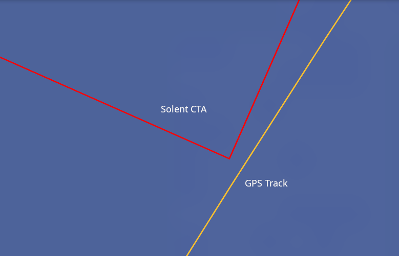
So what did show me inside controlled airspace? Just one radar — 120 km away, more than twice the distance of the Southampton radar and nearing the limits of its range. If you know anything about radar, you know the positional error increases linearly with distance due to azimuth error. Even if this distant radar were ten times more accurate than Southampton's (which it is not), it could not reliably determine whether I had infringed by 29 metres at that range.
The GPS said no infringement. Southampton's own radar said no infringement. One distant, less accurate radar said yes. The CAA chose that one — because it showed the conclusion they wanted.
This is not just my case
The CAA is pursuing pilots for alleged infringements based on evidence they know to be unreliable, using tools they know to be faulty, while suppressing the very information that would exonerate those pilots. Critical technical information about radar accuracy is deliberately withheld and misrepresented. Pilots' own evidence is dismissed while radar data — where a single plot can place an aircraft up to 926 metres from its true position — is treated as gospel. There is no symmetry of evidence, no presumption of innocence, and no fair hearing.
A public body pursuing individuals based on evidence from a system it knows to be unreliable, while suppressing exculpatory information. The Post Office insisted Horizon was infallible. The CAA insists radar is accurate to "a few centimetres." Both claims are demonstrably false. Both are used to sustain unjust findings against ordinary people.
Have you been through this?
I'd be very interested to hear from other pilots who've experienced similar issues with the CAA's enforcement process. If you get in touch, I will keep your information confidential unless otherwise agreed.